
Σούλι topographic map
Interactive map
Click on the map to display elevation.
About this map
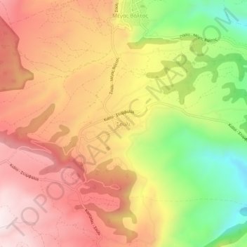
Name: Σούλι topographic map, elevation, terrain.
Average elevation: 1,959 ft
Minimum elevation: 702 ft
Maximum elevation: 2,907 ft
Other topographic maps
Click on a map to view its topography, its elevation and its terrain.
Kiato
Greece > Peloponnese, Western Greece and the Ionian > Corinthia Regional Unit > Municipal Unit of Sikyona
Kiato, Municipal Unit of Sikyona, Municipality of Sikyona, Corinthia Regional Unit, Peloponnese Region, Peloponnese, Western Greece and the Ionian, 202 00, Greece
Average elevation: 105 ft