
Gülbahçe Mahallesi topographic map
Interactive map
Click on the map to display elevation.
About this map
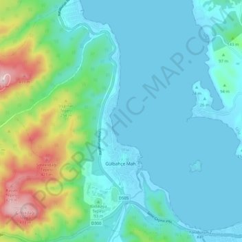
Name: Gülbahçe Mahallesi topographic map, elevation, terrain.
Location: Gülbahçe Mahallesi, Urla, Izmir, Aegean Region, 35433, Turkey (38.30650 26.59895 38.38663 26.67374)
Average elevation: 305 ft
Minimum elevation: -7 ft
Maximum elevation: 1,608 ft
Other topographic maps
Click on a map to view its topography, its elevation and its terrain.
İskele Mahallesi
İskele Mahallesi, Urla, Izmir, Aegean Region, Turkey
Average elevation: 180 ft