
Thank you for supporting this site ❤️
Make a donation
Make a donation
Gear up for your next adventure:
As an Amazon Associate, this site earns from qualifying purchases at no extra cost to you.
Huanchaco topographic map
Click on the map to display elevation.
Thank you for supporting this site ❤️
Make a donation
Make a donation
Gear up for your next adventure:
As an Amazon Associate, this site earns from qualifying purchases at no extra cost to you.
About this map
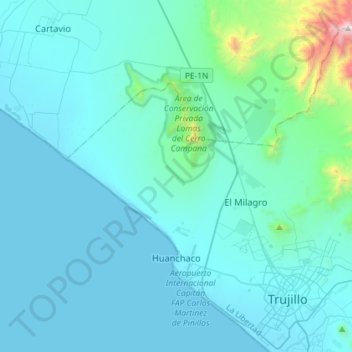
Name: Huanchaco topographic map, elevation, terrain.
Location: Huanchaco, Province of Trujillo, La Libertad, Peru (-8.13313 -79.21050 -7.89226 -78.92180)
Average elevation: 571 ft
Minimum elevation: -3 ft
Maximum elevation: 6,867 ft
Thank you for supporting this site ❤️
Make a donation
Make a donation
Gear up for your next adventure:
As an Amazon Associate, this site earns from qualifying purchases at no extra cost to you.