
Parque Nacional Los Glaciares topographic map
Interactive map
Click on the map to display elevation.
About this map
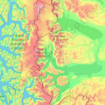
Name: Parque Nacional Los Glaciares topographic map, elevation, terrain.
Average elevation: 2,579 ft
Minimum elevation: -7 ft
Maximum elevation: 11,342 ft
Other topographic maps
Click on a map to view its topography, its elevation and its terrain.
Macrozona Lago Argentino
Macrozona Lago Argentino, El Calafate, Lago Argentino, SC, Argentine
Average elevation: 659 ft
El Calafate
El Calafate, Lago Argentino, SC, Z9405, Argentine
Average elevation: 1,102 ft