
Proaño topographic map
Interactive map
Click on the map to display elevation.
About this map
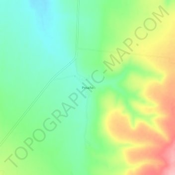
Name: Proaño topographic map, elevation, terrain.
Location: Proaño, Sombrerete, Zacatecas, México (23.71668 -103.68740 23.75668 -103.64740)
Average elevation: 7,635 ft
Minimum elevation: 7,461 ft
Maximum elevation: 7,923 ft
Other topographic maps
Click on a map to view its topography, its elevation and its terrain.
Colonia Ignacio Zaragoza
México > Zacatecas > Sombrerete
Colonia Ignacio Zaragoza, Sombrerete, Zacatecas, México
Average elevation: 7,080 ft