
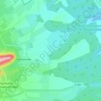
Hattonville topographic map
Interactive map
Click on the map to display elevation.
About this map
Name: Hattonville topographic map, elevation, terrain.
Average elevation: 781 ft
Minimum elevation: 702 ft
Maximum elevation: 1,171 ft
Other topographic maps
Click on a map to view its topography, its elevation and its terrain.
Hattonchâtel
France > Grand Est > Meuse > Vigneulles-lès-Hattonchâtel
Hattonchâtel, Vigneulles-lès-Hattonchâtel, Commercy, Meuse, Grand Est, France métropolitaine, 55210, France
Average elevation: 1,073 ft
Vigneulles-lès-Hattonchâtel
France > Grand Est > Meuse > Vigneulles-lès-Hattonchâtel
Vigneulles-lès-Hattonchâtel, Commercy, Meuse, Grand Est, France métropolitaine, 55210, France
Average elevation: 797 ft
Cochonville
France > Grand Est > Meuse > Vigneulles-lès-Hattonchâtel
Cochonville, Vigneulles-lès-Hattonchâtel, Commercy, Meuse, Grand Est, France métropolitaine, 55210, France
Average elevation: 886 ft