
Cerro de la Estrella topographic map
Interactive map
Click on the map to display elevation.
About this map
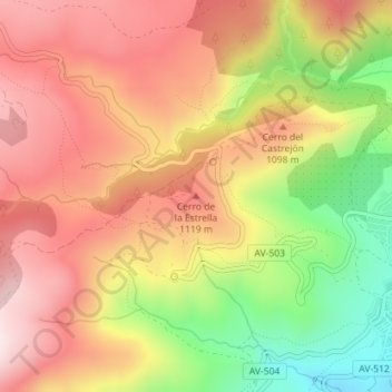
Name: Cerro de la Estrella topographic map, elevation, terrain.
Average elevation: 3,301 ft
Minimum elevation: 2,339 ft
Maximum elevation: 4,009 ft
Other topographic maps
Click on a map to view its topography, its elevation and its terrain.
Santa Leonor
España > Castilla y León > Cebreros
Santa Leonor, Cebreros, Ávila, Castilla y León, España
Average elevation: 2,356 ft