
Tscheltsch topographic map
Interactive map
Click on the map to display elevation.
About this map
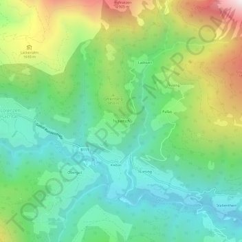
Name: Tscheltsch topographic map, elevation, terrain.
Average elevation: 4,337 ft
Minimum elevation: 2,986 ft
Maximum elevation: 7,139 ft
Other topographic maps
Click on a map to view its topography, its elevation and its terrain.
Niedergail
Österreich > Kärnten > Bezirk Hermagor > Lesachtal
Niedergail, Lesachtal, Bezirk Hermagor, Kärnten, 9653, Österreich
Average elevation: 4,203 ft
Maria Luggau
Österreich > Kärnten > Bezirk Hermagor > Lesachtal
Maria Luggau, Lesachtal, Bezirk Hermagor, Kärnten, 9655, Österreich
Average elevation: 4,754 ft
Hohe Warte
Österreich > Kärnten > Bezirk Hermagor > Lesachtal
Hohe Warte, Lesachtal, Bezirk Hermagor, Kärnten, Österreich
Average elevation: 6,969 ft