Geolocate

Rushmere St Andrew topographic map

Click on the map to display elevation.

About this map

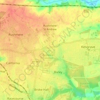
Name: Rushmere St Andrew topographic map, elevation, terrain.

Location: Rushmere St Andrew, East Suffolk, Suffolk, England, United Kingdom (52.04074 1.18680 52.08277 1.22786)

Average elevation: 121 ft

Minimum elevation: 20 ft

Maximum elevation: 180 ft

Other topographic maps

Click on a map to view its topography, its elevation and its terrain.

Wenhaston

United Kingdom > England > Suffolk > East Suffolk

Average elevation: 52 ft

Minsmere

United Kingdom > England > Suffolk > East Suffolk

Average elevation: 20 ft

Gear up for your next adventure:

💧Water Filtration Bottles - Safely drink from streams and lakes while exploring
🥩Freeze-Dried Meals - Nutritious and lightweight food for remote expeditions
🛠️Outdoor Gear Repair Kit - Essential tools to fix gear on the trail
📚Navigation Handbooks - Master the art of reading topographic maps and using a compass
🚁Photography Drones - Capture stunning aerial views of landforms and topography

As an Amazon Associate, this site earns from qualifying purchases at no extra cost to you.