
Galle topographic map
Interactive map
Click on the map to display elevation.
About this map
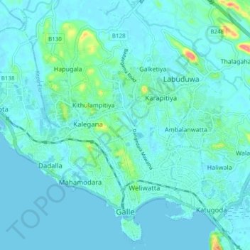
Name: Galle topographic map, elevation, terrain.
Location: Galle, Galle District, Southern Province, Sri Lanka (6.02359 80.17187 6.09397 80.24757)
Average elevation: 33 ft
Minimum elevation: -3 ft
Maximum elevation: 262 ft
Other topographic maps
Click on a map to view its topography, its elevation and its terrain.
Dangedara Junction
Sri Lanka > Southern Province > Galle
Dangedara Junction, Galle, Galle District, Southern Province, 80000, Sri Lanka
Average elevation: 36 ft
Galle
Sri Lanka > Southern Province > Galle
Galle, Galle District, Southern Province, 80000, Sri Lanka
Average elevation: 49 ft