
Thank you for supporting this site ❤️
Make a donation
Make a donation
Gear up for your next adventure:
As an Amazon Associate, this site earns from qualifying purchases at no extra cost to you.
Oberlech topographic map
Click on the map to display elevation.
Thank you for supporting this site ❤️
Make a donation
Make a donation
Gear up for your next adventure:
As an Amazon Associate, this site earns from qualifying purchases at no extra cost to you.
About this map
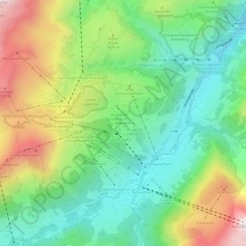
Name: Oberlech topographic map, elevation, terrain.
Location: Oberlech, Lech, Bezirk Bludenz, Vorarlberg, 6764, Austria (47.19844 10.11757 47.23844 10.15757)
Average elevation: 5,659 ft
Minimum elevation: 4,521 ft
Maximum elevation: 7,677 ft
Thank you for supporting this site ❤️
Make a donation
Make a donation
Gear up for your next adventure:
As an Amazon Associate, this site earns from qualifying purchases at no extra cost to you.