
La Hersonnais topographic map
Interactive map
Click on the map to display elevation.
About this map
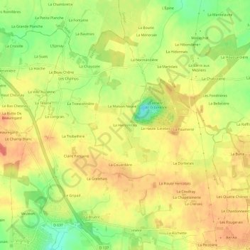
Name: La Hersonnais topographic map, elevation, terrain.
Average elevation: 351 ft
Minimum elevation: 243 ft
Maximum elevation: 420 ft
Other topographic maps
Click on a map to view its topography, its elevation and its terrain.
La Maison Neuve près le Bourg
France > Bretagne > Ille-et-Vilaine > Vignoc
La Maison Neuve près le Bourg, Vignoc, Rennes, Ille-et-Vilaine, Bretagne, France métropolitaine, 35630, France
Average elevation: 325 ft