
50600 topographic map
Interactive map
Click on the map to display elevation.
About this map
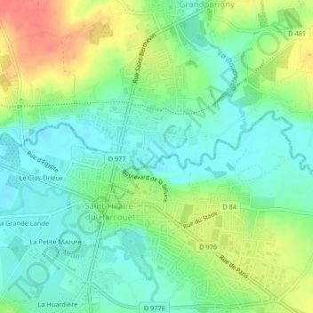
Name: 50600 topographic map, elevation, terrain.
Average elevation: 262 ft
Minimum elevation: 197 ft
Maximum elevation: 377 ft
Other topographic maps
Click on a map to view its topography, its elevation and its terrain.
Château de Parigny
France > Normandie > Manche > Grandparigny > La Blancherie
Château de Parigny, Route du Château, La Blancherie, Grandparigny, Avranches, Manche, Normandie, France métropolitaine, 50600, France
Average elevation: 276 ft
Grandparigny
France > Normandie > Manche > Grandparigny
Grandparigny, Avranches, Manche, Normandie, France métropolitaine, 50600, France
Average elevation: 295 ft