
Hamilton Dome topographic map
Interactive map
Click on the map to display elevation.
About this map
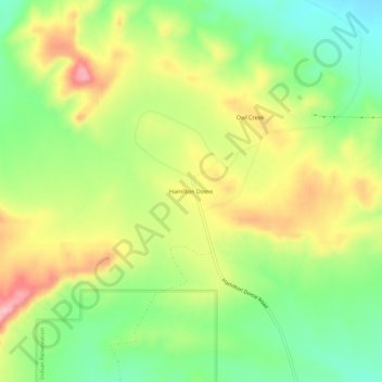
Name: Hamilton Dome topographic map, elevation, terrain.
Location: Hamilton Dome, Hot Springs County, Wyoming, United States (43.75329 -108.59567 43.79329 -108.55567)
Average elevation: 5,538 ft
Minimum elevation: 5,305 ft
Maximum elevation: 5,827 ft
Other topographic maps
Click on a map to view its topography, its elevation and its terrain.
Thermopolis
United States > Wyoming > Hot Springs County
Thermopolis, Hot Springs County, Wyoming, 82443, United States
Average elevation: 4,462 ft