
Ghezala topographic map
Interactive map
Click on the map to display elevation.
About this map
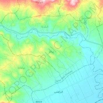
Name: Ghezala topographic map, elevation, terrain.
Average elevation: 846 ft
Minimum elevation: 407 ft
Maximum elevation: 2,343 ft
Other topographic maps
Click on a map to view its topography, its elevation and its terrain.
Tabarka
Tunisie > Gouvernorat Jendouba > Tabarka
Tabarka, Délégation Tabarka, Gouvernorat Jendouba, Tunisie
Average elevation: 151 ft
Ain Draham
Tunisie > Gouvernorat Jendouba
Ain Draham, Délégation Aïn Draham, Gouvernorat Jendouba, Tunisie
Average elevation: 2,395 ft