Geolocate

Orono topographic map

Click on the map to display elevation.

About this map

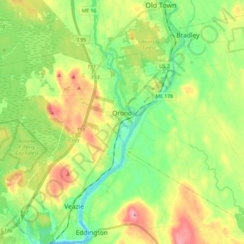
Name: Orono topographic map, elevation, terrain.

Location: Orono, Penobscot County, Maine, United States (44.84527 -68.80270 44.91291 -68.63752)

Average elevation: 144 ft

Minimum elevation: -7 ft

Maximum elevation: 371 ft

Penobscot County trails, hiking, mountain biking, running and outdoor activities

Other topographic maps

Click on a map to view its topography, its elevation and its terrain.

Bangor Hill

United States > Maine > Penobscot County > Orono

Average elevation: 203 ft

Hudson Hill

United States > Maine > Penobscot County > Hudson

Average elevation: 253 ft

Blackcap

United States > Maine > Penobscot County > Eddington

Average elevation: 571 ft

Sugar Island

United States > Maine > Penobscot County > Greenbush

Average elevation: 135 ft

Tiger Rips

United States > Maine > Penobscot County

Average elevation: 741 ft

State Island

United States > Maine > Penobscot County

Average elevation: 482 ft

Lincoln

United States > Maine > Penobscot County > Lincoln

Average elevation: 272 ft

Gear up for your next adventure:

🌧️Backpack Rain Cover - Keep gear dry in wet weather
🪓Survival Multi‑Tool - Versatile tool for camp and trail tasks
🧯Portable Fire Pit - Compact fire pit for camping spots
🪶Camping Sleeping Pad - Comfortable sleeping pad for backpacking
🧥Waterproof Jacket for Hiking - Breathable and rugged rain jacket for outdoor excursions

As an Amazon Associate, this site earns from qualifying purchases at no extra cost to you.