
Auf der Höhe topographic map
Interactive map
Click on the map to display elevation.
About this map
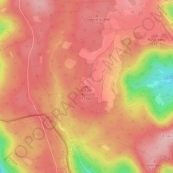
Name: Auf der Höhe topographic map, elevation, terrain.
Average elevation: 1,608 ft
Minimum elevation: 1,191 ft
Maximum elevation: 1,768 ft
Other topographic maps
Click on a map to view its topography, its elevation and its terrain.
Watterbach
Deutschland > Bayern > Landkreis Miltenberg > Kirchzell
Watterbach, Kirchzell, Landkreis Miltenberg, Bayern, Deutschland
Average elevation: 1,417 ft
Kirchzell
Deutschland > Bayern > Landkreis Miltenberg > Kirchzell
Kirchzell, Landkreis Miltenberg, Bayern, 63931, Deutschland
Average elevation: 1,191 ft