
Khouribga topographic map
Interactive map
Click on the map to display elevation.
About this map
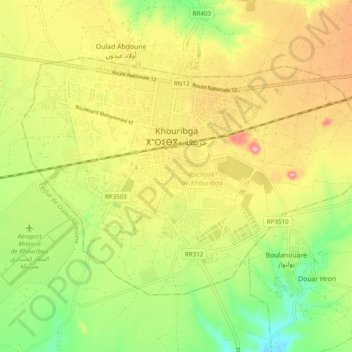
Name: Khouribga topographic map, elevation, terrain.
Average elevation: 2,575 ft
Minimum elevation: 2,329 ft
Maximum elevation: 2,841 ft
Other topographic maps
Click on a map to view its topography, its elevation and its terrain.
Khouribga
Maroc > Pachalik de Khouribga > Khouribga
Khouribga, Pachalik de Khouribga, Province de Khouribga, Béni Mellal-Khénifra, 25015, Maroc
Average elevation: 2,411 ft