
Outeiro Seco topographic map
Interactive map
Click on the map to display elevation.
About this map
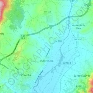
Name: Outeiro Seco topographic map, elevation, terrain.
Location: Outeiro Seco, Chaves, Vila Real, Portugal (41.74756 -7.47623 41.80792 -7.42806)
Average elevation: 1,283 ft
Minimum elevation: 1,129 ft
Maximum elevation: 2,037 ft
Other topographic maps
Click on a map to view its topography, its elevation and its terrain.
Vidago (União das freguesias de Vidago, Arcossó, Selhariz e Vilarinho das Paranheiras)
Vidago (União das freguesias de Vidago, Arcossó, Selhariz e Vilarinho das Paranheiras), Chaves, Vila Real, Portugal
Average elevation: 1,457 ft
Agrela de Ervededo
Portugal > Vila Real > Chaves > Ervededo
Agrela de Ervededo, Ervededo, Chaves, Vila Real, 5400-820, Portugal
Average elevation: 1,765 ft
Vilas Boas
Vilas Boas, Chaves, Vila Real, Portugal
Average elevation: 1,785 ft