
Make a donation
Gear up for your next adventure:
As an Amazon Associate, this site earns from qualifying purchases at no extra cost to you.
Fayetteville topographic map
Click on the map to display elevation.
Make a donation
Gear up for your next adventure:
As an Amazon Associate, this site earns from qualifying purchases at no extra cost to you.
About this map
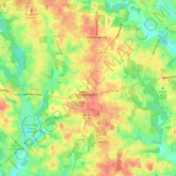
Name: Fayetteville topographic map, elevation, terrain.
Location: Fayetteville, Fayette County, Georgia, United States (33.41280 -84.52885 33.49112 -84.42163)
Average elevation: 869 ft
Minimum elevation: 768 ft
Maximum elevation: 968 ft
Fayette County trails, hiking, mountain biking, running and outdoor activities
Make a donation
Gear up for your next adventure:
As an Amazon Associate, this site earns from qualifying purchases at no extra cost to you.
Other topographic maps
Click on a map to view its topography, its elevation and its terrain.
Tamerlane
United States > Georgia > Fayette County > Peachtree City > Tamerlane
Average elevation: 810 ft