Geolocate

Cary topographic map

Click on the map to display elevation.

About this map

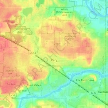
Name: Cary topographic map, elevation, terrain.

Location: Cary, McHenry County, Illinois, 60013, United States (42.19032 -88.29134 42.24052 -88.20971)

Average elevation: 820 ft

Minimum elevation: 719 ft

Maximum elevation: 919 ft

McHenry County trails, hiking, mountain biking, running and outdoor activities

Other topographic maps

Click on a map to view its topography, its elevation and its terrain.

6316

United States > Illinois > McHenry County > Ringwood

Average elevation: 801 ft

Riley

United States > Illinois > McHenry County

Riley, elevation 807 feet (246 m), is an unincorporated community and census-designated place in McHenry County, Illinois, United States. It was named a CDP before the 2020 census, at which time it had a population of 10.

Average elevation: 820 ft

Coral

United States > Illinois > McHenry County > Coral

Average elevation: 889 ft

Burtons Bridge

United States > Illinois > McHenry County

Average elevation: 758 ft

Gear up for your next adventure:

🧥Men's Rain Shells - Premium waterproof and breathable jackets for mountain weather
🧥Waterproof Jacket for Hiking - Breathable and rugged rain jacket for outdoor excursions
📶Vehicle Signal Boosters - Improve reception in rural areas while driving to trailheads
🪑Ultralight Camp Chairs - Portable seating for resting after a long day of mapping
🥩Freeze-Dried Meals - Nutritious and lightweight food for remote expeditions

As an Amazon Associate, this site earns from qualifying purchases at no extra cost to you.