
Sohar topographic map
Interactive map
Click on the map to display elevation.
About this map
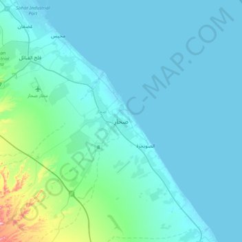
Name: Sohar topographic map, elevation, terrain.
Location: Sohar, Al Batinah North Governorate, 311, Oman (24.18456 56.58248 24.50456 56.90248)
Average elevation: 89 ft
Minimum elevation: -7 ft
Maximum elevation: 948 ft
Other topographic maps
Click on a map to view its topography, its elevation and its terrain.
Qasabiyat Al Bu Said
Oman > Al Batinah North Governorate
Qasabiyat Al Bu Said, Al Batinah North Governorate, Oman
Average elevation: 10 ft
Saham
Oman > Al Batinah North Governorate
Saham, Al Batinah North Governorate, 319, Oman
Average elevation: 131 ft