
Impasugong topographic map
Interactive map
Click on the map to display elevation.
About this map
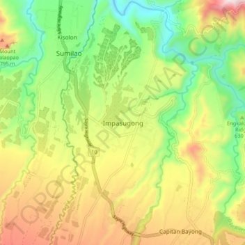
Name: Impasugong topographic map, elevation, terrain.
Location: Impasugong, Bukidnon, Northern Mindanao, Philippines (8.26605 124.95754 8.34605 125.03754)
Average elevation: 2,011 ft
Minimum elevation: 1,060 ft
Maximum elevation: 3,258 ft
Cool and moist throughout the year due to its high elevation ranging from 500 metres (1,600 ft) to more than 1,000 metres (3,300 ft) above sea level. It is a typhoon-free area ideal for the production of high value crops. Average temperature ranges from 16 to 31 °C (61 to 88 °F) throughout the year.
Other topographic maps
Click on a map to view its topography, its elevation and its terrain.
Impasugong
Philippines > Bukidnon > Impasugong
Impasugong, Bukidnon, Northern Mindanao, 8702, Philippines
Average elevation: 2,963 ft
Impalutao
Philippines > Bukidnon > Impasugong
Impalutao, Impasugong, Bukidnon, Northern Mindanao, 8702, Philippines
Average elevation: 2,523 ft