
Baume Auriol topographic map
Interactive map
Click on the map to display elevation.
About this map
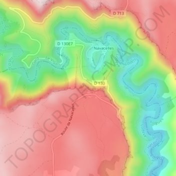
Name: Baume Auriol topographic map, elevation, terrain.
Average elevation: 1,654 ft
Minimum elevation: 899 ft
Maximum elevation: 2,290 ft
Other topographic maps
Click on a map to view its topography, its elevation and its terrain.
Navacelles
France > Occitanie > Hérault > Saint-Maurice-Navacelles
Navacelles, Saint-Maurice-Navacelles, Lodève, Hérault, Occitanie, France métropolitaine, France
Average elevation: 1,870 ft
La Clastre
France > Occitanie > Hérault > Saint-Maurice-Navacelles
La Clastre, Saint-Maurice-Navacelles, Lodève, Hérault, Occitanie, France métropolitaine, France
Average elevation: 1,867 ft