
Jolimont topographic map
Interactive map
Click on the map to display elevation.
About this map
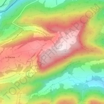
Name: Jolimont topographic map, elevation, terrain.
Location: Jolimont, Haute-Sorne, District de Delémont, Jura, 2863, Suisse (47.31007 7.19017 47.31017 7.19027)
Average elevation: 2,621 ft
Minimum elevation: 1,870 ft
Maximum elevation: 3,330 ft
Other topographic maps
Click on a map to view its topography, its elevation and its terrain.
Frénois
Suisse > Jura > Haute-Sorne
Frénois, Haute-Sorne, District de Delémont, Jura, 2863, Suisse
Average elevation: 2,333 ft
Undervelier
Suisse > Jura > Haute-Sorne
Undervelier, Haute-Sorne, District de Delémont, Jura, 2863, Suisse
Average elevation: 2,572 ft