Geolocate

Grad Rijeka topographic map

Click on the map to display elevation.

Grad Rijeka

Since records began in 1948, the highest temperature recorded at the local weather station at an elevation of 120 metres (390 ft) was 40.0 °C (104.0 °F), on 19 July 2007. The coldest temperature was −12.8 °C (9.0 °F), on 10 February 1956.

Wikipedia (CC-BY-SA 3.0)

About this map

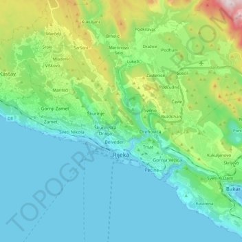
Name: Grad Rijeka topographic map, elevation, terrain.

Location: Grad Rijeka, Primorje-Gorski Kotar County, Croatia (45.30744 14.33193 45.38405 14.53097)

Average elevation: 686 ft

Minimum elevation: -3 ft

Maximum elevation: 3,205 ft

Other topographic maps

Click on a map to view its topography, its elevation and its terrain.

Rijeka

Croatia > Primorje-Gorski Kotar County

Average elevation: 1,260 ft

Jadranovo

Croatia > Primorje-Gorski Kotar County

Average elevation: 233 ft

Tribalj

Croatia > Primorje-Gorski Kotar County

Average elevation: 741 ft

Kalanji

Croatia > Primorje-Gorski Kotar County > Klenovica

Average elevation: 715 ft

Brešca

Croatia > Primorje-Gorski Kotar County

Average elevation: 1,230 ft

Liplje

Croatia > Primorje-Gorski Kotar County

Average elevation: 771 ft

Dolovo

Croatia > Primorje-Gorski Kotar County > Dolovo

Average elevation: 771 ft

Dolovo

Croatia > Primorje-Gorski Kotar County > Dolovo

Average elevation: 771 ft

Janjevalj

Croatia > Primorje-Gorski Kotar County > Tribalj

Average elevation: 1,033 ft

Radovanj

Croatia > Primorje-Gorski Kotar County

Average elevation: 1,611 ft

Selo

Croatia > Primorje-Gorski Kotar County

Average elevation: 2,848 ft

Belo

Croatia > Primorje-Gorski Kotar County

Average elevation: 1,148 ft

Turke

Croatia > Primorje-Gorski Kotar County

Average elevation: 1,663 ft

Sunger

Croatia > Primorje-Gorski Kotar County

Average elevation: 2,910 ft

Gomirje

Croatia > Primorje-Gorski Kotar County

Average elevation: 1,414 ft

Rova

Croatia > Primorje-Gorski Kotar County > Zidarići

Average elevation: 135 ft

Seka

Croatia > Primorje-Gorski Kotar County

Average elevation: 46 ft

Šmrika

Croatia > Primorje-Gorski Kotar County

Average elevation: 541 ft

Rudine

Croatia > Primorje-Gorski Kotar County

Average elevation: 59 ft

Punat

Croatia > Primorje-Gorski Kotar County

Average elevation: 308 ft

Gear up for your next adventure:

🧦Merino Wool Socks - Moisture-wicking, blister-preventing socks for long treks
🏥Hiking First Aid Kits - Comprehensive medical kits for remote trail injuries
🌡️Portable Weather Meter - Track weather conditions on the trail
🔋Solar Power Banks - Keep your GPS and phone charged in remote wilderness areas
📷Action Cameras - Rugged cameras to document your journeys across rugged terrain

As an Amazon Associate, this site earns from qualifying purchases at no extra cost to you.