
Make a donation
Gear up for your next adventure:
As an Amazon Associate, this site earns from qualifying purchases at no extra cost to you.
Lakehurst topographic map
Click on the map to display elevation.
Make a donation
Gear up for your next adventure:
As an Amazon Associate, this site earns from qualifying purchases at no extra cost to you.
Lakehurst
The borough's lake, Lake Horicon, existed prior to 1942, as clearly shown in aerial photographs from 1940 and 1931 and topographical maps from 1912. The cedar water lake remains stream-fed.
Make a donation
Gear up for your next adventure:
As an Amazon Associate, this site earns from qualifying purchases at no extra cost to you.
About this map
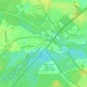
Name: Lakehurst topographic map, elevation, terrain.
Location: Lakehurst, Ocean County, New Jersey, United States (40.00414 -74.33177 40.02164 -74.29847)
Average elevation: 69 ft
Minimum elevation: 36 ft
Maximum elevation: 102 ft
Ocean County trails, hiking, mountain biking, running and outdoor activities
Make a donation
Gear up for your next adventure:
As an Amazon Associate, this site earns from qualifying purchases at no extra cost to you.
Other topographic maps
Click on a map to view its topography, its elevation and its terrain.
Barnegat Beach
United States > New Jersey > Ocean County > Ocean Township > Waretown
Average elevation: 13 ft
Make a donation
Gear up for your next adventure:
As an Amazon Associate, this site earns from qualifying purchases at no extra cost to you.
Make a donation
Gear up for your next adventure:
As an Amazon Associate, this site earns from qualifying purchases at no extra cost to you.
Make a donation
Gear up for your next adventure:
As an Amazon Associate, this site earns from qualifying purchases at no extra cost to you.
Story Island Channel
United States > New Jersey > Ocean County > Little Egg Harbor Township
Average elevation: 0 ft
Make a donation
Gear up for your next adventure:
As an Amazon Associate, this site earns from qualifying purchases at no extra cost to you.