
Thank you for supporting this site ❤️
Make a donation
Make a donation
Gear up for your next adventure:
As an Amazon Associate, this site earns from qualifying purchases at no extra cost to you.
Leominster topographic map
Click on the map to display elevation.
Thank you for supporting this site ❤️
Make a donation
Make a donation
Gear up for your next adventure:
As an Amazon Associate, this site earns from qualifying purchases at no extra cost to you.
About this map
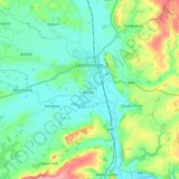
Name: Leominster topographic map, elevation, terrain.
Location: Leominster, Herefordshire, England, United Kingdom (52.18211 -2.81482 52.24667 -2.65927)
Average elevation: 331 ft
Minimum elevation: 203 ft
Maximum elevation: 712 ft
Thank you for supporting this site ❤️
Make a donation
Make a donation
Gear up for your next adventure:
As an Amazon Associate, this site earns from qualifying purchases at no extra cost to you.
Other topographic maps
Click on a map to view its topography, its elevation and its terrain.
Symonds Yat East
United Kingdom > England > Herefordshire > Goodrich > Symonds Yat East
Average elevation: 318 ft