
Nore topographic map
Interactive map
Click on the map to display elevation.
About this map
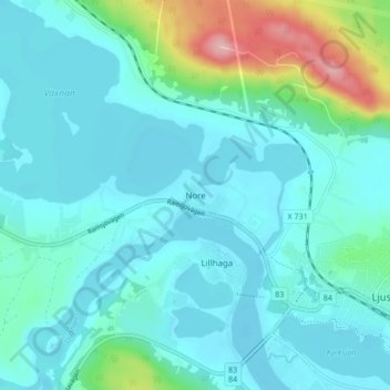
Name: Nore topographic map, elevation, terrain.
Location: Nore, Ljusdals kommun, Comté de Gävleborg, 827 30, Suède (61.81966 16.03336 61.85966 16.07336)
Average elevation: 466 ft
Minimum elevation: 390 ft
Maximum elevation: 843 ft
Other topographic maps
Click on a map to view its topography, its elevation and its terrain.
Hamra
Hamra, Ljusdals kommun, Comté de Gävleborg, Suède
Average elevation: 1,434 ft
Tärnön
Suède > Comté de Gävleborg > Agö hamn
Tärnön, Agö hamn, Hudiksvalls kommun, Comté de Gävleborg, Suède
Average elevation: 16 ft
Gävle
Gävle, Gävle kommun, Comté de Gävleborg, Suède
Average elevation: 89 ft
Hofors kommun
Hofors kommun, Comté de Gävleborg, Suède
Average elevation: 482 ft
Söderhamn
Söderhamn, Söderhamns kommun, Comté de Gävleborg, 826 30, Suède
Average elevation: 79 ft