
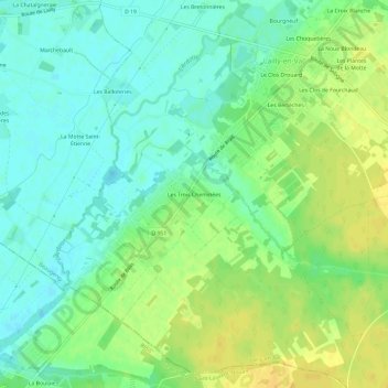
Les Trois Cheminées topographic map
Interactive map
Click on the map to display elevation.
About this map
Name: Les Trois Cheminées topographic map, elevation, terrain.
Average elevation: 292 ft
Minimum elevation: 256 ft
Maximum elevation: 335 ft
Other topographic maps
Click on a map to view its topography, its elevation and its terrain.
Le Gros Melon
France > Centre-Val de Loire > Loiret > Lailly-en-Val
Le Gros Melon, Lailly-en-Val, Orléans, Loiret, Centre-Val de Loire, France métropolitaine, 45740, France
Average elevation: 295 ft
Château de Pully
France > Centre-Val de Loire > Loiret > Lailly-en-Val > Le Grand Aunay
Château de Pully, D 19, Le Grand Aunay, Lailly-en-Val, Orléans, Loiret, Centre-Val de Loire, France métropolitaine, 45740, France
Average elevation: 341 ft
Le Clos Drouard
France > Centre-Val de Loire > Loiret > Lailly-en-Val
Le Clos Drouard, Lailly-en-Val, Orléans, Loiret, Centre-Val de Loire, France métropolitaine, 45740, France
Average elevation: 295 ft