
Regenstauf topographic map
Interactive map
Click on the map to display elevation.
About this map
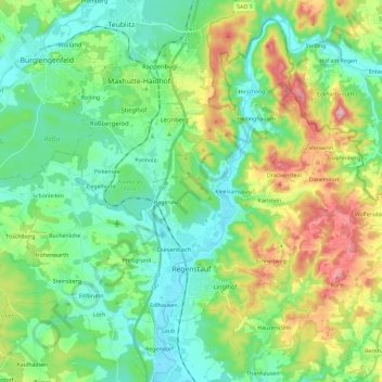
Name: Regenstauf topographic map, elevation, terrain.
Location: Regenstauf, Landkreis Regensburg, Bayern, 93128, Deutschland (49.08654 12.00369 49.22328 12.23586)
Average elevation: 1,348 ft
Minimum elevation: 1,086 ft
Maximum elevation: 1,985 ft
Other topographic maps
Click on a map to view its topography, its elevation and its terrain.
Frauenzell
Deutschland > Bayern > Landkreis Regensburg
Frauenzell, Brennberg, Wörth an der Donau (VGem), Landkreis Regensburg, Bayern, 93179, Deutschland
Average elevation: 1,716 ft
Stettwies
Deutschland > Bayern > Landkreis Regensburg > Lappersdorf > Lorenzen
Stettwies, Lorenzen, Lappersdorf, Landkreis Regensburg, Bayern, 93138, Deutschland
Average elevation: 1,240 ft
Irlbründl
Deutschland > Bayern > Landkreis Regensburg > Regenstauf > Kürnberg
Irlbründl, Kürnberg, Regenstauf, Landkreis Regensburg, Bayern, 93128, Deutschland
Average elevation: 1,243 ft