
Sponheim topographic map
Interactive map
Click on the map to display elevation.
About this map
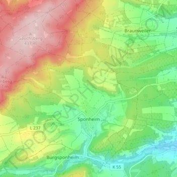
Name: Sponheim topographic map, elevation, terrain.
Average elevation: 919 ft
Minimum elevation: 525 ft
Maximum elevation: 1,440 ft
Other topographic maps
Click on a map to view its topography, its elevation and its terrain.
Meddersheim
Germany > Rhineland-Palatinate > Landkreis Bad Kreuznach
Meddersheim, Nahe-Glan, Landkreis Bad Kreuznach, Rhineland-Palatinate, Germany
Average elevation: 748 ft
Seesbach
Germany > Rhineland-Palatinate > Landkreis Bad Kreuznach
Seesbach, Nahe-Glan, Landkreis Bad Kreuznach, Rhineland-Palatinate, 55629, Germany
Average elevation: 1,263 ft
Bad Kreuznach
Germany > Rhineland-Palatinate > Landkreis Bad Kreuznach
Bad Kreuznach, Landkreis Bad Kreuznach, Rhineland-Palatinate, Germany
Average elevation: 591 ft
Kirn
Germany > Rhineland-Palatinate > Landkreis Bad Kreuznach
Kirn, Kirner Land, Landkreis Bad Kreuznach, Rhineland-Palatinate, Germany
Average elevation: 991 ft
Dörrebach
Germany > Rhineland-Palatinate > Landkreis Bad Kreuznach
Dörrebach, Langenlonsheim-Stromberg, Landkreis Bad Kreuznach, Rhineland-Palatinate, 55444, Germany
Average elevation: 1,345 ft
Gutenberg
Germany > Rhineland-Palatinate > Landkreis Bad Kreuznach
Gutenberg, Rüdesheim, Landkreis Bad Kreuznach, Rhineland-Palatinate, Germany
Average elevation: 702 ft