
Les Bassines topographic map
Interactive map
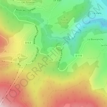
Click on the map to display elevation.
About this map
Name: Les Bassines topographic map, elevation, terrain.
Average elevation: 3,612 ft
Minimum elevation: 2,897 ft
Maximum elevation: 4,475 ft
Other topographic maps
Click on a map to view its topography, its elevation and its terrain.
Les Pinasses
France > Auvergne-Rhône-Alpes > Chalmazel-Jeansagnière > Chalmazel > Les Pinasses
Les Pinasses, Chalmazel, Chalmazel-Jeansagnière, Montbrison, Loire, Auvergne-Rhône-Alpes, France métropolitaine, 42920, France
Average elevation: 3,665 ft
Les Granges
France > Auvergne-Rhône-Alpes > Chalmazel-Jeansagnière
Les Granges, Chalmazel, Chalmazel-Jeansagnière, Montbrison, Loire, Auvergne-Rhône-Alpes, France métropolitaine, 42920, France
Average elevation: 4,613 ft