
Bream topographic map
Interactive map
Click on the map to display elevation.
About this map
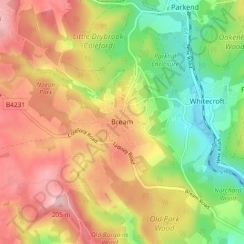
Name: Bream topographic map, elevation, terrain.
Average elevation: 400 ft
Minimum elevation: 105 ft
Maximum elevation: 689 ft
Other topographic maps
Click on a map to view its topography, its elevation and its terrain.
Coleford
United Kingdom > England > Gloucestershire > Forest of Dean
Coleford, Forest of Dean, Gloucestershire, England, United Kingdom
Average elevation: 633 ft
Yorkley
United Kingdom > England > Gloucestershire > Forest of Dean
Yorkley, Forest of Dean, Gloucestershire, England, GL15 4TL, United Kingdom
Average elevation: 371 ft