
Obertshausen topographic map
Interactive map
Click on the map to display elevation.
About this map
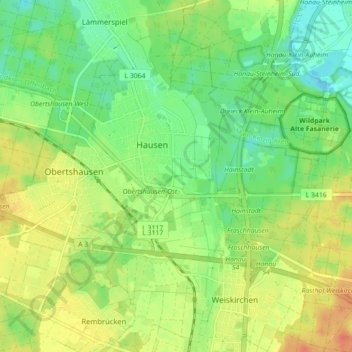
Name: Obertshausen topographic map, elevation, terrain.
Location: Obertshausen, Landkreis Offenbach, Hesse, 63179, Allemagne (50.05053 8.82166 50.09503 8.91015)
Average elevation: 387 ft
Minimum elevation: 325 ft
Maximum elevation: 463 ft
Other topographic maps
Click on a map to view its topography, its elevation and its terrain.
Neu-Isenburg
Allemagne > Hesse > Landkreis Offenbach
Neu-Isenburg, Landkreis Offenbach, Hesse, 63263, Allemagne
Average elevation: 430 ft
Dietzenbach
Allemagne > Hesse > Landkreis Offenbach
Dietzenbach, Landkreis Offenbach, Hesse, 63128, Allemagne
Average elevation: 509 ft
Langen
Allemagne > Hesse > Landkreis Offenbach
Langen, Landkreis Offenbach, Hesse, 63225, Allemagne
Average elevation: 449 ft