
Malga Ciapela topographic map
Interactive map
Click on the map to display elevation.
About this map
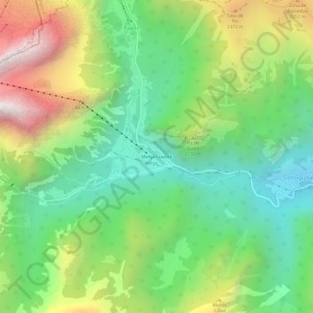
Name: Malga Ciapela topographic map, elevation, terrain.
Location: Malga Ciapela, Rocca Pietore, Belluno, Veneto, 32023, Italia (46.40767 11.89179 46.44767 11.93179)
Average elevation: 6,122 ft
Minimum elevation: 4,091 ft
Maximum elevation: 9,603 ft
Other topographic maps
Click on a map to view its topography, its elevation and its terrain.
Punta Rocca
Italia > Veneto > Belluno > Rocca Pietore
Punta Rocca, Rocca Pietore, Belluno, Veneto, Italia
Average elevation: 8,724 ft