
El Affroun topographic map
Interactive map
Click on the map to display elevation.
About this map
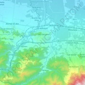
Name: El Affroun topographic map, elevation, terrain.
Location: El Affroun, Daïra El Affroun, Blida, Algérie (36.37648 2.56259 36.51641 2.65305)
Average elevation: 761 ft
Minimum elevation: 184 ft
Maximum elevation: 4,318 ft
Other topographic maps
Click on a map to view its topography, its elevation and its terrain.
Beni Mouimen
Algérie > Blida > Daïra El Affroun > El Affroun > Beni Mouimen
Beni Mouimen, El Affroun, Daïra El Affroun, Blida, 09200, Algérie
Average elevation: 459 ft