
Make a donation
Gear up for your next adventure:
As an Amazon Associate, this site earns from qualifying purchases at no extra cost to you.
Kraj Vysočina topographic map
Click on the map to display elevation.
Make a donation
Gear up for your next adventure:
As an Amazon Associate, this site earns from qualifying purchases at no extra cost to you.
Kraj Vysočina
The region is located in the central part of the Czech Republic, partly in the southeast of the historical region of Bohemia and partly in the southwest of the historical region of Moravia. The entire Vysočina Region is located in the nature region of Bohemian-Moravian Highlands, from whose colloquial name vysočina (meaning "the highlands") the region got its name. Within the country, the region has a relatively high altitude and is the source of many rivers. The most important rivers are the Sázava, Jihlava, Svratka and Oslava.
Make a donation
Gear up for your next adventure:
As an Amazon Associate, this site earns from qualifying purchases at no extra cost to you.
About this map
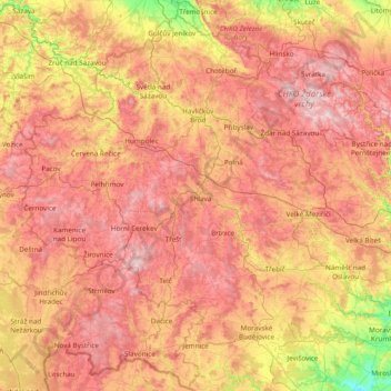
Name: Kraj Vysočina topographic map, elevation, terrain.
Location: Kraj Vysočina, Southeast, Czechia (48.93759 14.88818 49.86122 16.41830)
Average elevation: 1,686 ft
Minimum elevation: 646 ft
Maximum elevation: 2,766 ft
Make a donation
Gear up for your next adventure:
As an Amazon Associate, this site earns from qualifying purchases at no extra cost to you.
Other topographic maps
Click on a map to view its topography, its elevation and its terrain.