Geolocate

Oyón/Oion topographic map

Click on the map to display elevation.

About this map
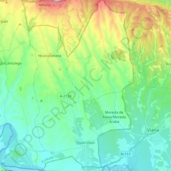
Name: Oyón/Oion topographic map, elevation, terrain.

Location: Oyón/Oion, Arabako Errioxa/Rioja Alavesa, Álava, Autonomous Community of the Basque Country, 01320, Spain (42.48664 -2.48398 42.60692 -2.38967)

Average elevation: 1,877 ft

Minimum elevation: 1,211 ft

Maximum elevation: 3,760 ft

Other topographic maps

Click on a map to view its topography, its elevation and its terrain.
Gear up for your next adventure:

🚑Emergency Bivvies - Heat-reflective sleeping bags for survival situations
📱Heavy-Duty Phone Cases - Drop-proof and waterproof protection for outdoor navigation
🧥Waterproof Jacket for Hiking - Breathable and rugged rain jacket for outdoor excursions
🪵Folding Camp Saw - Compact saw for wood and campsite work
🦟Ultrasonic Repellers - Create a bug-free zone at your camp or rest stop

As an Amazon Associate, this site earns from qualifying purchases at no extra cost to you.