Geolocate

Libon topographic map

Click on the map to display elevation.

About this map

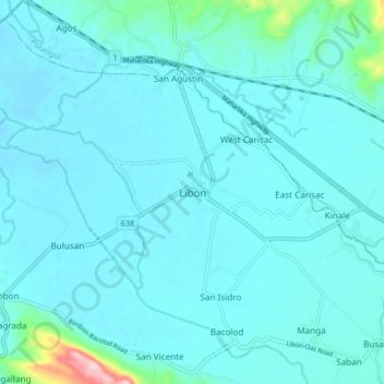
Name: Libon topographic map, elevation, terrain.

Location: Libon, Albay, Bicol Region, 4507, Philippines (13.25887 123.39608 13.33887 123.47608)

Average elevation: 89 ft

Minimum elevation: 10 ft

Maximum elevation: 879 ft

Other topographic maps

Click on a map to view its topography, its elevation and its terrain.

Peñaranda Park

Philippines > Albay > Legazpi > Baño

Average elevation: 121 ft

Malilipot

Philippines > Albay

Average elevation: 860 ft

Rapu-Rapu

Philippines > Albay

Average elevation: 59 ft

Gear up for your next adventure:

🪑Portable Camp Table - Compact table for campsite meals
🎒Hydration Pack - Hands‑free water reservoir for long hikes
🧴Hand Sanitizer - Keep hands clean while hiking
🪶Thermal Camp Blanket - Extra warmth for cold nights
🚗GPS Dash Cams - Record your scenic drives through mountain passes and canyons

As an Amazon Associate, this site earns from qualifying purchases at no extra cost to you.