Geolocate

Acklins Island topographic map

Click on the map to display elevation.

About this map

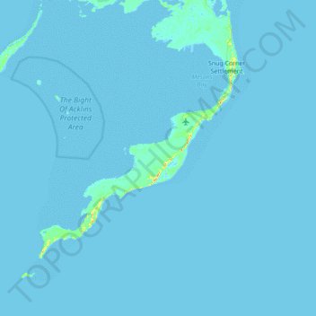
Name: Acklins Island topographic map, elevation, terrain.

Location: Acklins Island, Acklins, The Bahamas (22.04728 -74.34877 22.68728 -73.70877)

Average elevation: 0 ft

Minimum elevation: -7 ft

Maximum elevation: 115 ft

Gear up for your next adventure:

🕶️GPS Smartphone Mount - Secure mount for phone navigation
❄️Traction Cleats - Prevent slips on icy trails during winter hikes
🛡️Bear Spray Outdoor - Protection in bear country hikes
📶Satellite Messenger - Communication device off‑grid
🥄Camping Utensil Set - Lightweight utensils for outdoor meals

As an Amazon Associate, this site earns from qualifying purchases at no extra cost to you.