
Make a donation
Gear up for your next adventure:
As an Amazon Associate, this site earns from qualifying purchases at no extra cost to you.
Dautphetal topographic map
Click on the map to display elevation.
Make a donation
Gear up for your next adventure:
As an Amazon Associate, this site earns from qualifying purchases at no extra cost to you.
Dautphetal
Dautphetal's municipal area is classified under the German system of natural regions as follows: The Sackpfeifen foothills (with Wollenberg) (Sackpfeifen-Vorhöhen (mit Wollenberg)) (natural region 332.0) in the area north of the Upper Lahn Valley (Oberes Lahntal) falls under the main unit Ostsauerländer Gebirgsrand. The natural region of the Upper Lahn Valley, 320.2, Bottenhorn Plateau (Bottenhorner Hochflächen, 320.01) as well as the Damshausen Hills (Damshäuser Kuppen, 320.10) belong to the Gladenbach Uplands (Gladenbacher Bergland). The highest mountain in this area is the Nimerich (533 m above sea level) northwest of the constituent community of Dautphe. The lowest point anywhere in the area is found on the river Lahn at Elmshausen, where the elevation is 225 m above sea level. East of the community's municipal lands at Damshausen lies the Rimberg (mountain, 498 m above sea level).
Make a donation
Gear up for your next adventure:
As an Amazon Associate, this site earns from qualifying purchases at no extra cost to you.
About this map
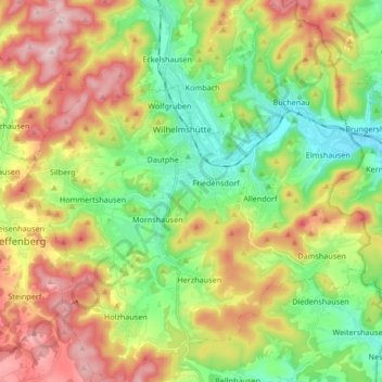
Name: Dautphetal topographic map, elevation, terrain.
Location: Dautphetal, Landkreis Marburg-Biedenkopf, Hesse, 35232, Germany (50.79629 8.48028 50.90194 8.63274)
Average elevation: 1,194 ft
Minimum elevation: 741 ft
Maximum elevation: 1,841 ft
Make a donation
Gear up for your next adventure:
As an Amazon Associate, this site earns from qualifying purchases at no extra cost to you.