
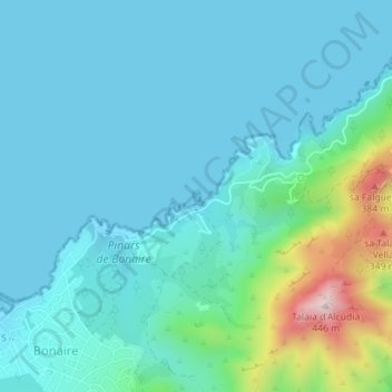
s'Illot topographic map
Interactive map
Click on the map to display elevation.
About this map
Name: s'Illot topographic map, elevation, terrain.
Average elevation: 226 ft
Minimum elevation: 0 ft
Maximum elevation: 1,398 ft
Other topographic maps
Click on a map to view its topography, its elevation and its terrain.
Punta de sa Guarda de Tacàritx
España (mare territorial) > Islas Baleares > Alcudia
Punta de sa Guarda de Tacàritx, Alcudia, Raiguer, Islas Baleares, 07400, España (mare territorial)
Average elevation: 98 ft
S'Albufereta
España (mare territorial) > Islas Baleares > Alcudia
S'Albufereta, Maris C, Puerto de Alcudia, Alcudia, Raiguer, Islas Baleares, 07408, España (mare territorial)
Average elevation: 7 ft