
Barrage Sidi Salem topographic map
Interactive map
Click on the map to display elevation.
About this map
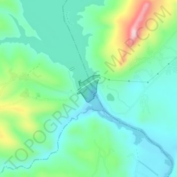
Name: Barrage Sidi Salem topographic map, elevation, terrain.
Location: Barrage Sidi Salem, Mezougha, Testour, Béja, Tunisie (36.58789 9.39462 36.59198 9.39909)
Average elevation: 456 ft
Minimum elevation: 220 ft
Maximum elevation: 1,119 ft
Other topographic maps
Click on a map to view its topography, its elevation and its terrain.
Téboursouk
Tunisie > Béja > Téboursouk
Téboursouk, Teboursouk Ville, Teboursouk, Béja, 9040, Tunisie
Average elevation: 1,319 ft
Barrage Sidi El Barrak
Barrage Sidi El Barrak, Ezzouaraa, Nefza, Béja, Tunisie
Average elevation: 157 ft