
Mid Calder topographic map
Interactive map
Click on the map to display elevation.
About this map
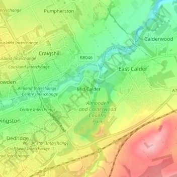
Name: Mid Calder topographic map, elevation, terrain.
Location: Mid Calder, West Lothian, Scotland, EH53 0AN, United Kingdom (55.87035 -3.50205 55.91035 -3.46205)
Average elevation: 440 ft
Minimum elevation: 223 ft
Maximum elevation: 732 ft
Other topographic maps
Click on a map to view its topography, its elevation and its terrain.
Livingston
United Kingdom > Scotland > West Lothian
Livingston, West Lothian, Scotland, EH54 6HS, United Kingdom
Average elevation: 518 ft
Ecclesmachan
United Kingdom > Scotland > West Lothian
Ecclesmachan, West Lothian, Scotland, EH52 6NG, United Kingdom
Average elevation: 387 ft
East Calder
United Kingdom > Scotland > West Lothian
East Calder, West Lothian, Scotland, EH53 0EL, United Kingdom
Average elevation: 459 ft