
Kudat topographic map
Click on the map to display elevation.
About this map
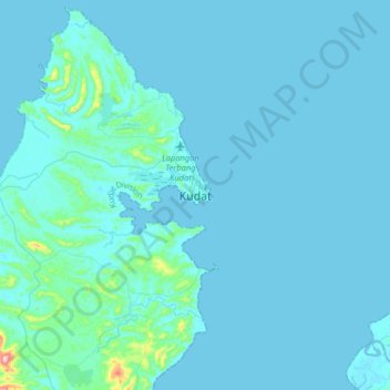
Name: Kudat topographic map, elevation, terrain.
Location: Kudat, Kudat Division, Sabah, 89050, Malaysia (6.72303 116.68938 7.04303 117.00938)
Average elevation: 62 ft
Minimum elevation: -3 ft
Maximum elevation: 1,283 ft
Other topographic maps
Click on a map to view its topography, its elevation and its terrain.
Banggi Island
Banggi Island (Malay: Pulau Banggi) is located within the Kudat Division of Sabah in Malaysia. With an area of 440.7 square kilometres, it is the largest island in Malaysia followed by Bruit Island, Langkawi Island and Penang Island. It is located off the northern coast of Sabah near Marudu Bay. The highest…
Average elevation: 69 ft