
Colla topographic map
Interactive map
Click on the map to display elevation.
About this map
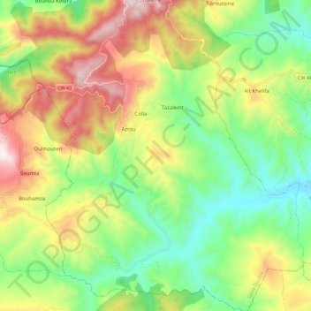
Name: Colla topographic map, elevation, terrain.
Location: Colla, Daïra Djaafra, Bordj Bou Arreridj, Algérie (36.20206 4.62447 36.29189 4.71736)
Average elevation: 3,166 ft
Minimum elevation: 2,142 ft
Maximum elevation: 4,606 ft
Other topographic maps
Click on a map to view its topography, its elevation and its terrain.
Azrou
Algérie > Bordj Bou Arreridj > Daïra Djaafra
Azrou, Colla, Daïra Djaafra, Bordj Bou Arreridj, Algérie
Average elevation: 3,363 ft