
Make a donation
Gear up for your next adventure:
As an Amazon Associate, this site earns from qualifying purchases at no extra cost to you.
Glen Allen topographic map
Click on the map to display elevation.
Make a donation
Gear up for your next adventure:
As an Amazon Associate, this site earns from qualifying purchases at no extra cost to you.
About this map
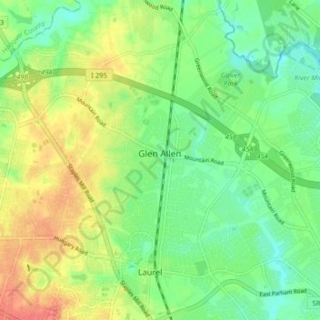
Name: Glen Allen topographic map, elevation, terrain.
Location: Glen Allen, Henrico County, Virginia, United States (37.63523 -77.52748 37.69417 -77.44831)
Average elevation: 203 ft
Minimum elevation: 102 ft
Maximum elevation: 292 ft
Henrico County trails, hiking, mountain biking, running and outdoor activities
Make a donation
Gear up for your next adventure:
As an Amazon Associate, this site earns from qualifying purchases at no extra cost to you.
Other topographic maps
Click on a map to view its topography, its elevation and its terrain.
Laurel West
United States > Virginia > Henrico County > Glen Allen > Laurel West
Average elevation: 210 ft