
Narachan topographic map
Interactive map
Click on the map to display elevation.
About this map
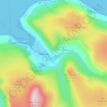
Name: Narachan topographic map, elevation, terrain.
Average elevation: 564 ft
Minimum elevation: 0 ft
Maximum elevation: 1,611 ft
Other topographic maps
Click on a map to view its topography, its elevation and its terrain.
Caldron Well
Vereinigtes Königreich > Schottland > North Ayrshire
Caldron Well, North Ayrshire, Schottland, KA24 5HU, Vereinigtes Königreich
Average elevation: 722 ft
Isle of Arran
Vereinigtes Königreich > Schottland > North Ayrshire
Isle of Arran, North Ayrshire, Schottland, Vereinigtes Königreich
Average elevation: 322 ft