
Pradell de la Teixeta topographic map
Interactive map
Click on the map to display elevation.
About this map
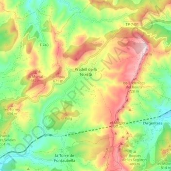
Name: Pradell de la Teixeta topographic map, elevation, terrain.
Average elevation: 1,611 ft
Minimum elevation: 919 ft
Maximum elevation: 2,510 ft
Other topographic maps
Click on a map to view its topography, its elevation and its terrain.
la Vilella Baixa
Spanje > Catalonië > Priorat > la Vilella Baixa > la Vilella Baixa
la Vilella Baixa, Priorat, Tarragona, Catalonië, 43374, Spanje
Average elevation: 1,099 ft